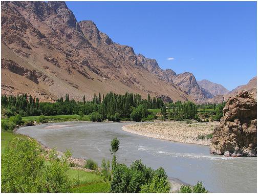
The Amu Darya River is the largest water stream in Central Asia. Its length is 1415 kilometers, and the water intake basin is more than 309 thousand square kilometers. It flows through the territory of five states: Afghanistan, Uzbekistan, Turkmenistan, Tajikistan and Kyrgyzstan. The river is formed by Vakhsh and Panj in a confluence. The main stock is formed in Tajikistan - 85% and Northern Afghanistan - 15%. The Amu Darya flows into the Aral Sea, near which it forms a delta. The river has 3 large right tributaries: Sherabad, Kafirnigan and Surkhandarya. There is a small left tributary - Kunduz. The river is made up of glacial and melt water. 80% of the water is regulated by 36 reservoirs with a volume of 24 billion cubic meters. The annual river flow is 73.6 km 3 . The maximum water flow is in summer, the minimum is in January and February.
The economic importance of the Amu Darya
This river is vital for a huge number of people living in its pool. Its waters are used for domestic needs, generating electricity, agriculture, for drinking purposes and industrial consumption. In the lower reaches of the river and floodplain lakes, fishing is developed. In the area of Turkmenabad, the Amu Darya River is navigable. Most of the waters are disassembled by agriculture for irrigation of fields, since this activity is an important sector of the economies of all 5 countries - up to 35% of GDP. For example, in Afghanistan, up to 80% of the population is employed in this area. Turkmenistan and Uzbekistan take away more than others for agricultural needs - up to 40%. On the Amu Darya, the largest channel in the world was built - the Karakum, along which giant fields of wheat and cotton are located. Watermelons and melons are also grown in large numbers.
History
The river has been known since time immemorial. The ancient Greek historian Herodotus wrote that the Amu Darya in ancient times, 40 mouths went into the marshes and had 360 canals, but only one sleeve flowed into the Caspian Sea. But modern scientists have found that the water flow reached only Lake Sarykamysh. Thus, the information of the ancient chronicler was most likely based on oral traditions. In ancient times, the Amu Darya bore many names. Zoroastrians called it Vaksh, Arkhara, Rakh or Ranha. The ancient Greeks called Araks. And during the conquests of Alexander the Great, the river was called Oxos. The great states of antiquity were located along the banks of the Amu Darya: Khorezm, Bactria and Sogdiana. In the Middle Ages, the trade route from Russia to Bukhara went along the Amu Darya. Peter I actively tried to draw the river into Russian trade. In those days, the Amu Darya River was explored. The map of that time is pretty accurate. Systematic studies of the river began only in the 20th century. Then they began to observe the composition of the water.
Ecology
The load on the Amu Darya in recent decades has increased, which has caused a sharp deterioration in the composition of water. Imbalance also occurred. The Amu Darya River today shows alarming parameters of mineralization and hardness. For example, in 1940, water hardness was 4.2 mg.eq / liter. In the 90th year - 9. And today - 9.8 mg.eq / liter. The concentration of salts depends on the season. These indicators are due to the massive discharge of industrial and industrial waters into the river, and surface runoff and emissions from river fleet vessels are also important. As the river flows through the territory of several states, the problems of its purification are complex efforts. To date, governments in all five countries have drawn up plans and signed treaties.
Fishing
Fish are found in the lower reaches of the river and in the lakes of the Amu Darya basin. The main prey for fishermen is carp, salmon, asp, marinka and barbel. But in the upper reaches there is also a fish - Ottoman, which replaces trout on the river. These are objects of fishing, and more than a hundred different species are found in the waters of the Amu Darya. Marinka, barbel and ottoman are quite unique living creatures that are found mainly in the Amu Darya. They have antennae, which they seek for prey in troubled waters. Osman differs from barbel and marinka in that its tail and sides are covered with small rare scales, the belly is completely bare, and there are also 2 additional antennae. Fishing on the Amu Darya lasts from May to October. You can catch spinning, donks and half bastards.
Tourism
Rafting enthusiasts love to come here. Both the Amu Darya and the Syr Darya are attractive in this regard - there are several interesting places. The route begins a few kilometers from Tashkent. The peak of the alloy occurs in mid-September and October. Lovers of history and travel come here from all over the world in order to admire the ancient majestic cities and visit the Amu Darya Reserve. Along the banks of the river there are several climatic zones: desert, semi-desert and mountains. One -humped and two-humped camels living in the Red Book of the snow leopard live in this region. In addition, the miraculous Lake Mollakara is located here, where many diseases are cured. Here, the ancient city of the time of Alexander the Great, Nis, once bloomed. The Amu Darya is the eternal charm of history.