The Yellow River, which is translated from Chinese as “yellow river”, is one of the largest rivers in Asia. This name is associated with a huge amount of sediment, which gives its waters a yellow tint. The sea into which the river flows also has a yellowish color and is called Yellow. The Yellow River takes its beginning in the mountains of Tibet, on the eastern slope of the highlands, at an altitude of more than 4 thousand meters. Then the river begins to descend from the mountains, passes through 2 suitable lakes (Dzharin-Nur and Orin-Nur) and down the spurs of mountain ranges descends into the valley. Here it crosses 2 desert plateaus (Loess and Ordos) and forms a huge bend. Then the river follows through the gorges of the Shanghai mountains and flows into the Great Plain. Here, its length is more than 700 kilometers. The mouth of the river is located at the Bahai Bay. The Yellow River basin area is 770 thousand square kilometers, and its length is about 5 thousand kilometers.
Geography of the Yellow River
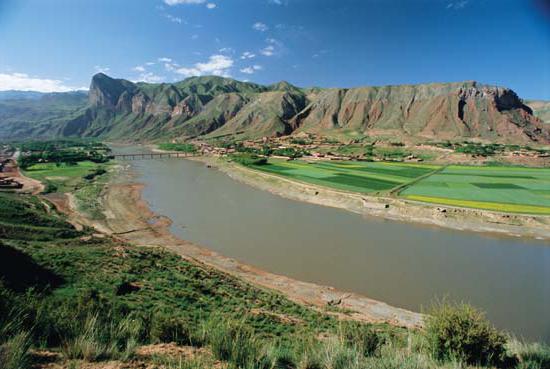
The yellow river in China flows through 7 provinces: Shandong, Shaanxi, Henan, Inner Mongolia, Qinghai, Ningxia Hui and Gansu. The Yellow River is usually divided into three parts: the lower, middle and upper reaches. The first is located on the Great Plain of China. The average is between Shaanxi province and the Ordos Plateau. Upper - from the origins of the Tibetan Plateau to the Loess Plateau. The Yellow River is one of the deepest in the world. The Yellow River basin provides drinking, industrial and agricultural water to more than 140 million people. Her channel is extremely mobile and she often leaves the coast. Floods bring numerous disasters, which served as the birth of the second name of the river - "China's Misfortune." But reverse phenomena were also observed, for example, in the 90s of the last century, Yellow River more than once completely dried up in the northern regions.
Yellow River Floods
Over 3 thousand years, the Yellow River more than one and a half thousand times left the coast and 26 times changed its direction. To protect against floods, the Yellow River has built many dams and diversion channels, which, however, do not change the situation on the river. Studies by American scientists have shown that buildings not only do not stop the problem, but even provoke it, since for more than 3 thousand years people have blocked the river's natural course. Waterworks slow down the river, thereby causing sedimentation at the bottom. As a result, water rises again, and the strength of floods increases from time to time. People are building even more powerful dams and deep diversion channels, but the Yellow River is increasingly coming out of the shores. Such a struggle between man and the river can lead to unforeseen consequences.
History of the Yellow River
Ancient maps of the first rulers of China show that the Yellow River flowed north of its current channel. In 2356 BC , a flood occurred on it, the Yellow River changed its course and began to flow into Gili Bay. After 2 thousand years, drainage channels and dams began to be built on the river, and it began to flow into the Yellow Sea. One of the military tactics of warring dynasties was the flooding of the enemy army or its territories. So, in the year 11 AD, the flood caused the fall of the Xin Dynasty. Also, hydraulic structures were destroyed in 923 in order to protect the capital of the Liang dynasty from the attack of the Tang dynasty. From the second millennium AD, the Yellow River itself regularly broke through dams. One of the most severe floods occurred in 1887, it claimed 2 million lives.
Yellow River Life
The Yellow River regime is monsoon. From July to October, the water rises to 5 meters on the Great Plain, and in the mountains it can rise up to 20 meters. The river freezes in the middle and lower reaches. In the lower one - up to 3 weeks, on average - for 2 months (January and February). The Yellow River annually discharges up to 1.9 billion tons of sediment. By this indicator, the river leads among other waterways of the world. So on the plain in some places the bottom can rise up to 12 meters above the surface of the terrain. The yellow river has hydraulic structures with a length of 5 thousand kilometers, their height sometimes exceeds 12 meters. During floods, water is up to 800 kilometers wide. Navigable Yellow River mainly on the Great Plain. The length of the navigable channel is 790 kilometers. The yellow river is connected by a channel with the Yangtze and Huaihe rivers .
Nature and Attractions of Yellow River
The yellow river is very attractive for vegetation and animals. Everyone wants water. For example, only in its delta 1542 species of animals live and 393 species of plants grow. In the middle reaches of the Yellow River is the largest Hukou waterfall on the river, 20 meters high. It is one of the most interesting and picturesque places on the planet. The usual width of the waterfall is 30 meters, and at the time of the river flood it reaches 50. Below Hukou there is a huge rock that divides the stream into two parts. In the mountainous areas of the river is a national nature reserve - Sanjianyuan. There are 2 beautiful alpine lakes. It is extremely attractive for both the Chinese themselves and for tourists from abroad. Millions of people from all over the world come here every year.