A point on the surface of the earth, designated as the center of a country or continent, has great potential in terms of tourism business. In the age of selfie, to fix your presence in the center of any part of the world is a matter of honor for any traveler.
The center of Europe today does not have a universally recognized location; several villages and cities in different countries claim its title.
Calculation methods
The ambiguity of determining a geographical center stems from the variety of methods for calculating it. They come down to several options:
- Calculation of the position of the center of gravity of the area of certain shapes.
- The projection of the center of gravity on the surface of the Earth, taking into account the sphericity of the planet.
- Finding a point equidistant from the borders of the territory.
- The calculation of the location of the point of intersection of the segments pairwise connecting the extreme northern and southern, western and eastern points is the median center.
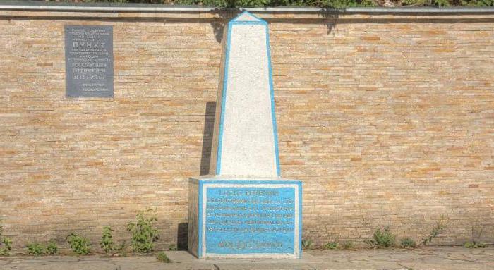
In the last way, the geographical center of Europe was determined in 1775 by the court astronomer and cartographer of the Polish king Augustus, Shimon Anthony Sobekraisky. The point of intersection of the lines connecting Portugal and the Central Urals, Norway and Southern Greece was located at the point with coordinates 53 ° 34'39 "N, 23 ° 06'22" in. e. In this place, in the town of Suchowol, near Białystok, on the territory of modern Poland, a memorial sign was erected.
Calculations in the 19th century
In 1815, the center of Europe was placed at the point with coordinates 48 ° 44'37 "N, 18 ° 55'50" in. The village, which was located near the town of Kremnica, near the Baptist Church of St. John, on the territory of modern Slovakia. Calculation methods have not been preserved, but there is a version that this is the center of the smallest circle inscribed in the outlines of Europe. How its borders were determined is also unknown.
In 1887, the geographers of the Austro-Hungarian Empire, when laying new railways in Transcarpathia, installed a marker with coordinates 48 ° 30 's. W, 23 ° 23 'in. etc., defining it as the midpoint of the extreme values of the latitude and longitude of the Old World. The center of Europe in their version is located on the banks of the Tisza, near the Ukrainian village of Delovoy. In Soviet times, the truth of the calculations was confirmed, and a whole propaganda campaign was conducted to convince everyone of the truth of this version of the geographical center of Europe.
Another center of the European part of the world was defined at the end of the 19th century in the form of Mount Tillenberg near the city of Eger in Czech Bohemia, where a memorial sign was also installed, and this fact was actively used for advertising purposes by the authorities of neighboring villages.
The most “untwisted” monument
In 1989, scientists at the French National Geographic Institute clarified the boundaries of the European part of the world and determined by calculating the center of gravity of the geometric shape determined by the outlines of the oldest part of the world that the geographical center of Europe is at a point with coordinates 54 ° 54 's. W, 25 ° 19 'in. It is located in Lithuania, 26 km from Vilnius, near the village of Purnushkiai.
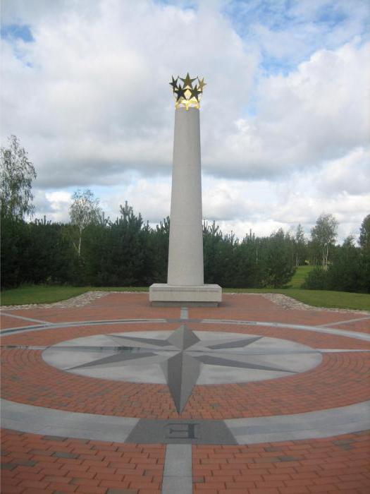
The State Department of Tourism of this country appreciated the importance of this place as a means of attracting foreign visitors, and in 2004 a European park was opened here. It includes a sculpture park, where more than 90 works by contemporary artists from 27 countries are represented. The geographical center of Europe is marked by a monument created by the outstanding Lithuanian sculptor Gedeminas Jokubonis. It is a snow-white granite column crowned with a crown of golden stars. The Lithuanian version of the center of the Old World is the only one listed in the Guinness Book of Records.
Hungary, Estonia
In 1992, another measurement was carried out, as a result of which it was argued that the center of Europe is located in Hungary, in the village of Tallia, at a point of 48 ° 14 's. W, 21 ° 13 'in. e. A memorial sign has also been erected here.
Most measurements do not include in the territory of Europe small islands belonging to European states. If we take into account the Portuguese Azores in the Atlantic, Franz Josef Land in the Arctic Ocean, Crete and Iceland, it turns out that the center of Europe is located on the island of Saaremaa, in the western part of Estonia. The local municipality is trying to clarify these calculations and organize in the village of Mönnuste, which is closest to the point 58 ° 18'14 "N, 22 ° 16'44" in. village, a tourist area dedicated to this attraction.
Polotsk, Belarus
At the beginning of the XXI century, studies of Belarusian scientists A. Solomonov and V. Anoshko were published. They used a special computer program in which the location of the coordinates of the geographical center of Europe was subject to a special algorithm related to the inclusion in our part of the world of the area of internal and external water areas and the Ural Range as its eastern border.
Scientists from the Russian Central Research Institute of Geodesy and Cartography have confirmed the correctness of this approach and the correctness of calculations. According to them, it turns out that the geographical center of the Old World is located in Belarus, in the city of Polotsk, and has coordinates 55 ° 30'0 "N, 28 ° 48'0" in. e. A small monument with a symbolic designation of this point was opened in May 2008.
Subject to political change
There is a belief that it is necessary to calculate this significant point only for the member countries of the European Union. Given that the number of countries included in this association is changing, the settlement point is moving accordingly, villages and cities in the center of Europe are changing.
The French National Geographic Institute (IGN) has recorded this shift since 1987, depending on changes in the number of EU countries :
- 12 countries (1987) - the village of Saint-André-le-Koc in the central region of France, after the reunification of Germany (1990) moved 25 km to the north-east, to the town of Noiret.
- 15 countries (2004) - the town of Viruanval, Belgium.
- 25 states (2007) - the village of Kleinmeischeid, the land of Rhineland-Palatinate, Germany.
- 27 countries (2007) - after the accession of Romania and Bulgaria - near the city of Heinhausen, Hesse, Germany.
- 28 countries (2013) - forty kilometers from Frankfurt, where the headquarters of the European Central Bank is located, which is even symbolic.