The Central Siberian Plateau lies in the north of Eurasia. The area is about one and a half million kilometers. What is the position of the Central Siberian Plateau on a geographical map? From the south of the area lie the Sayan Mountains, Transbaikalia and Pribaikalye are located. The western part borders on the West Siberian plain, the northern one on the North Siberian lowland, the eastern one on the Central Yakut plain.
Description of the area
The length of the Central Siberian Plateau from south to north is about 3 thousand kilometers. The territory was formed by sedimentary rocks of the Paleozoic, partly Mesozoic. The area is also characterized by reservoir intrusions: basalt covers and traps. The region is rich in deposits of iron, copper and nickel ores, graphite, coal and salt. It produces diamonds and natural gas. The climate is sharply continental, and remains almost the entire territory, despite the fact that the length of the Central Siberian Plateau is quite impressive. Winter is frosty: air temperature - 20-40 degrees, maximum - up to -70. Summer is cool or relatively warm (12-20 degrees). Precipitation per year decreases from west to east - from 800 to 200 millimeters. Permafrost is almost universally prevalent. The western slopes of the Putorana plateau are particularly snow-covered. Among the largest rivers are the Lower Tunguska, Angara, Podkamennaya Tunguska, Vilyui, Lena, Khatanga. These and other water flows belong to the basin of the Arctic Ocean. The Central Siberian plateau, the length of which, as indicated above, is quite large, is mainly covered by larch (light coniferous) taiga. Pine-larch and pine forests are widespread in the southern part.
Characteristics of the Central Siberian Plateau
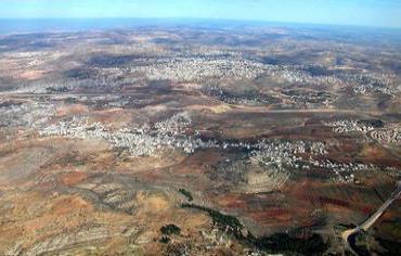
A significant part of the territory is occupied by a plateau. It is a wide and flat interfluve, most often boggy. The Central Siberian Plateau, whose average height is not more than 500-700 m, in some areas rises above 1000 m (up to a maximum of 1071). The base of the platform is occupied by the Archean-Proterozoic folded foundation. On it is a sedimentary cover of the late period. The thickness of the layer is about 10-12 kilometers. In the northern and southwestern parts of the rock, they protrude to the surface (Aldan shield, Anabaisk massif, Pribaikalsky uplift). The thickness of the crust is generally 25-30 km, in some areas up to 45 kilometers. The relief of the Central Siberian Plateau is such that this area rises significantly above sea level.
The foundation of the territory
The platform consists of several types of rocks. Among them, one can distinguish marbles, crystalline schists, charnockites and others. According to experts, some of them are about three to four billion years old. The sedimentary cover is not made up of such ancient deposits. The formation of these rocks belongs to the period of the origin of mankind. Paleozoic sediments are penetrated by igneous rocks. They were formed during the time of numerous eruptions, solidification in sedimentary rocks. These layers are called traps. Due to the alternation of these layers with sedimentary (more fragile) rocks, a stepped relief of the territory was formed. Most often, traps are found in the area of the Tunguska Depression. In the Mesozoic, the Central Siberian Plateau for the most part experienced a rise. As a result, the Putorana Plateau formed. This point is the highest in the whole territory. Surface elevation continued in the Cenozoic. In the same period, a river network began to form. In addition to the Putorana plateau, intense uplift was observed in the Yenisei and Anabar massifs. Subsequent processes led to changes in the river network. Such is the tectonic structure of the Central Siberian Plateau. It should be said that some traces of river systems that existed in antiquity have survived to our time. The mobility and power of glaciers in this territory was insignificant, therefore they did not have a special effect on the relief (as in other parts of the planet, for example). The rise continued in the postglacial period.
Description of river systems
The Central Siberian Plateau is a plain with a gently undulating relief with interfluve and deep (in some places canyon-like) river valleys. The greatest depth of the pools is up to a thousand meters. Such formations are often found in the west of the Putorana plateau. The smallest depth is up to 100 m. Such sites are found in the Central Tunguska Plateau, the North Siberian and Central Yakut Lowlands. Almost all river valleys in Central Siberia are canyon-shaped and asymmetric.
A distinctive feature of the pools is a large number (from six to nine) of terraces. These sites indicate repeated tectonic uplifts of the territory. In the North Siberian lowland and in the Taimyr river valleys formed in later periods. At the same time, there are fewer terraces there - even in the largest basins there are no more than three or four of them.
Features of the device of the earth's crust
Four relief groups stand out throughout the territory:
- Ridges, ridge-plateaus, plateaus and mid-mountain ranges. The latter are located on the protrusions in the crystalline basement.
- Plateau and reservoir hills. They are found in Paleozoic sedimentary rocks.
- Stratum-accumulative and accumulative plains.
- Volcanic plateau.
The direction of the Central Siberian Plateau began to form from antiquity. It should be said that the processes are happening today. The shifts in antiquity and now coincide in direction. However, this is not characteristic of the whole area. Erosion processes in the territory where the Central Siberian Plateau is located are hampered by permafrost. It prevents, among other things, the formation of karst forms of the crust - natural wells, caves, a number of rocks (gypsum, chalk, limestone and others). In the area where the Central Siberian Plateau is located, ancient glacial relic formations uncharacteristic for other regions of Russia are found. Karst forms are found only in a number of southern regions. In these territories there is no permafrost. These include, in particular, the Leno-Aldan and Leno-Angarsk plateaus. However, the main small relief forms throughout the area are still cryogenic and erosive. The strongest monsoons in the sharply continental climate contributed to the formation of a large number of rocky placers and screes on the plateau surfaces, slopes of river valleys and in mountain ranges. Permafrost is prevalent almost everywhere in the area. Its conservation is favored by the low average annual temperature and the peculiarities of the cold period inherent in the climate. Among other things, the territory is characterized by small cloud cover, which contributes to the night radiation of heat. The diversity of the soil is associated with heterogeneity of rocks, humidity, topography, features of the plant world, and temperature conditions. The environment has a significant impact on the species composition of flora and fauna, as well as on the external color, number, and also the way of life of animals and the development of vegetation.
Vegetation and wildlife
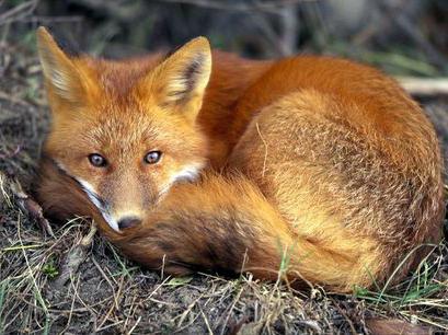
Taiga occupies about 70% of the entire territory. In the Central Siberian Plateau, it prevails on a light coniferous forest, consisting of Siberian larch in the west and Daurian in the east. Dark coniferous plants are pushed to the extreme western regions. Due to the not very humid and relatively warm summers in this area, more than anywhere else, forests are advanced to the north. In a harsh climate, the hairline of fur animals has acquired a silkiness and special splendor. The fauna of the taiga is very diverse. Of predatory animals, foxes, wolverines, ermines, columns, sables, and others are common here. From ungulates the territory is inhabited by musk deer and moose. Rodents are very common in the taiga, squirrels are especially numerous. This beast is in a special place in the fur trade. The main habitats of the squirrel are the dark coniferous taiga. Of the remaining rodents, a rather numerous species are the vole, the hare, the chipmunk. Among the feathered individuals, white partridges and hazel grouse are common. In 1930, the muskrat was introduced into the territory of the Central Siberian Plateau. This animal inhabits mainly slow rivers, water bodies, where a large number of marsh vegetation. Many animals distributed on the territory are much larger than their relatives living in milder climatic conditions.
Putorana Plateau
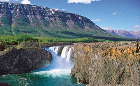
In the northern part lies a somewhat strange, deserted, but beautiful place. "The Lost World" - this is what journalists call this territory. The few tourists who have been here speak of this area as a region with ten thousand lakes and a thousand waterfalls. The Putorana Plateau is a mysterious and majestic area that is unlike any other. There are many gorges, lakes, crystal waterfalls and transparent rivers. Bright northern flowers stand out against the background of snow and stones.
Brief description of the territory
The Putorana Plateau lies beyond the borders of the Arctic Circle. This is the highest point in the Central Siberian Plateau. It was formed, according to scientists, about 10-12 million years ago. The formation of the territory was facilitated by a powerful earthquake that affected a significant part of Eurasia. The process led to the formation of large islands in the Kara and Barents Seas. After the earthquake, the climate changed (severe cold began to prevail), as well as wildlife and vegetation. Today, the plateau is in some way a "layer cake" formed by a huge number of lava outflows. In some places of basalt formations, there are about two dozen. Almost all the time during the year, snow is on the peaks. Thanks to this, there are so many water sources in the territory. Snow melting begins in August.
Legends of the Putorana Plateau
The epos of the northern peoples holds many legends about this lost area. Nganasans, Nenets and Evenks, who have lived on its territory since ancient times, believe that the Fiery God lives here - the tormentor of human souls, the owner of hell. According to scientists, these beliefs are associated with relatively recent (4-5 thousand years ago) volcanic eruptions. According to one of the Evenki legends, a fiery spirit, escaping from the abyss, soared above Khatanga, causing the river to boil, searing villages, burning taiga, destroying cattle and people. On the plateau is Lake Khantai. The local population calls it the Cup of Tears. This lake is considered one of the deepest in all of Russia. The depth of the pool reaches five hundred meters. Previously, Khantai Lake was considered sacred. Nenets and Evenki girls came to him for centuries to complain about their share of the goddess Eshnu and see their future fate in its waters. According to ancient legend, the Fiery God in time immemorial killed the only son of the goddess Eshnu. The owner of hell took his immortal soul to his underground lair. Heartbroken, Ashnu cried for a very long time, until she turned into a basalt black rock. Her tears filled the once dried-up hollow. So the Cup of tears was formed.
Life on the Putorana Plateau Today
For many decades, there has been only one permanent settlement on its territory. Not far from Lake Agatha is a weather station. About ten people are present at it, they are monitoring the weather changes around the clock. But meteorologists also observe mysterious phenomena, the description of which does not fall into the summaries. For example, as the oldest employees of the weather station recall, every year from December 25 to January 7, from the seventies of the last century, almost every evening in the area of the hundred-meter-long frozen Khabarba Falls, concentric rotating circles rise into the sky from the earth. In a few minutes they form a luminous giant spiral extending high into the starry sky. This phenomenon lasts no more than fifteen minutes. After that, the spiral fades, dissolving in the dark. There is another mystery of the Putorana Plateau. From time to time, geometric scorched figures — triangles, ovals, circles — appear on the surface — hexagonal natural pavers.
Processes occurring in the earth's crust, and the nearest forecasts
Today, for no apparent reason, the plateau rises one and a half centimeters annually, as a result of which the tectonic faults of the foundation are deepening. This circumstance allows us to assume that quite intensive processes are taking place underground. Given the increasing geological activity everywhere, scientists are increasingly saying that in the near (foreseeable) future, another natural disaster can be expected on the territory. Experts suggest three likely scenarios. In the first case, instead of a plateau, a young but very active volcanic formation is formed. The second scenario assumes a series of powerful earthquakes in the coming century. As a result of these processes, a new mountain formation split the Central Siberian Plateau from north to south to the eastern Sayans. In the third, worst case, serious geological processes will occur, similar in intensity to a large-scale natural disaster. As a result, a giant fault can occur at the junction of the Siberian platform and the West Siberian plate in the Yenisei basin. As a result, the Taimyr Peninsula will turn into an island, while the waters from the Laptev Sea will flood the formed continental crevice.