The island of Matua is a piece of land uninhabited today, which is often covered with dense fog, giving this mysterious place even more mystery.
general characteristics
This is the most unexplored island of the Kuril ridge. Its dimensions are relatively small: length - 11 km, width - 6.5 km. The highest point is the peak Sarycheva (Fuyu volcano) - its height is 1485 meters. The significant distance from the populated areas of Sakhalin and Kamchatka, the presence of an active volcano and the mysterious historical facts associated with this place are the reason that the island is now uninhabited. It should be noted that after the surrender of Japan in August 1945 for several decades there was an active border outpost on the island. But in 2000, it was destroyed by fire. Since then, the island of Matua has become completely deserted. Only occasionally do expeditions come here, whose members struggle over the clues of the secrets of this small piece of land.
Island history
The first mention of the island was found in the reports of researcher Ivan Kozyrevsky. He was one of the first to give a detailed description of the Kuril Islands, having visited some of them, and gave them names. He named Matua the island of Motogo. This place is also mentioned in the research diaries of the Cossack centurion Ivan Cherny, who reached Iturup in 1766-1769. He calls Matua the island of Mutova. It was Ivan Cherny who first mentioned the Fuyu volcano, calling it a hill. Based on information from the stories of the smokers, he tells how a burning hill caused monstrous rockfalls, from which all living things died within a radius of several kilometers.
Until the 20th century, the island of Matua was the site of a permanent settlement of the Ainu. It is also known that in 1923 there was the village of Matsua-mura, in which several hundred Japanese lived. Then the island was part of the internal territory of Japan, and most likely, it was in the 20-30s that the construction of all military facilities and communications began here. The fact is that during the Second World War, the island of Matua was the most important strategic object of Japan. It became the most powerful fortress with which the entire northwestern part of the Pacific was controlled.
Secrets of the island of Matua
However, in addition to the obvious facts proving that there was an airfield, fuel depots and aircraft themselves, there is reason to believe that the island of Matua was the Japanese secret base where they could develop chemical and bacteriological weapons.
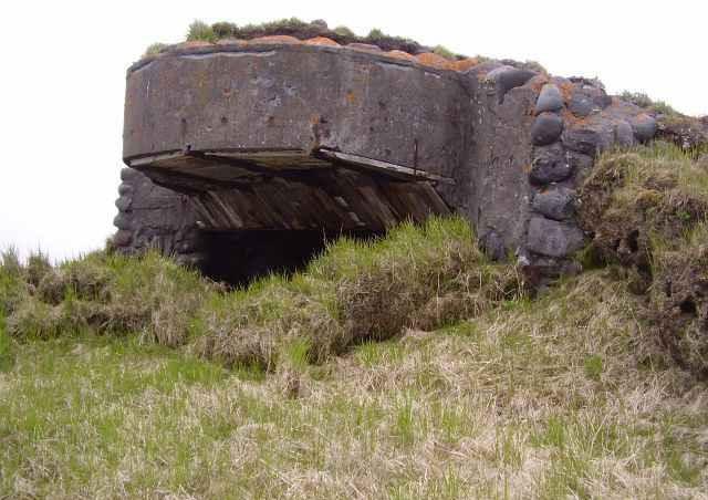
The fact is that in addition to the airfield itself and a whole network of defensive structures (bunkers, bunkers, caponiers, trenches, ditches), which are in the public domain, there are many underground structures on the island whose purpose is still unknown. Are these chemical laboratories, camouflaged warehouses, bomb shelters, barracks or a command post? This question is unlikely to ever be unambiguously answered. Most of the objects are hidden deep underground, the entrances to them are blocked up as a result of explosions and eruptions. But a large number of cast-iron and ceramic pipes stick out from under the ground. According to the stories of the expedition members, there is also a disguised water tower and concrete bunkers with steel doors and shutters. The fact that laboratory tests could be carried out on the island are also indicated by sensors, manometers, centrifuges, fragments of flasks and test tubes found in piles of iron. But if this is so, then where did the main equipment and equipment go? And the main question is where are the laboratories themselves.
For many years, the permanent leader of the Kamchatka-Kuril expedition, Yevgeny Mikhailovich Vereshchaga, has been searching for answers to these questions. He, like many other researchers, was inclined to believe that the
Japanese island of Matua was mothballed before the Japanese surrendered to Soviet troops. Historical facts speak in favor of this version. On August 18, Soviet troops landed on the Kuril Islands, and information about this spread throughout the islands. The garrison of Matua officially capitulated on August 25th. That is, the Japanese had time to take out all the valuables, and that which cannot be taken out, should be hidden deep underground.
Most likely, just before the surrender, more than 10 thousand soldiers managed to leave the island. And those 3811 Japanese who surrendered are those soldiers who were engaged in preserving the island and hiding everything.
One cannot but pay attention to how thoughtfully the Japanese approached the construction of the airfield. The runways on it are so high-quality lined with concrete that to this day its condition is no worse than, for example, in Sheremetyevo. In total, three runways were equipped, two of which are parallel to each other, and the third - at an angle of 45 degrees with respect to the others. This is no coincidence. Two parallel ones were used as the main ones, and the third one was used when a strong wind blew from the sea. Until now, hundreds of barrels of fuel are scattered around the airfield, on which the Wehrmacht markings are visible. And some of them are complete.
Post-war time
Already after the Japanese military evacuated from Matua, and the Russians settled there, strange things happened on the island: either people disappeared, sometimes the light illuminated the slopes of the volcano at night ... And in the late 60s, three border guards found one of the entrances to the dungeon, and, driven by curiosity, went down there. No one else saw them. It was after this incident that the government was banned from entering the Japanese catacombs.
Territorial dispute with Japan
To this day, Russia and Japan cannot divide the Kuril Islands. The border with Japan has not changed since the Second World War, after which all the islands of the Kuril ridge were included in the Soviet Union. However, the Japanese side now claims to own the southern islands of Iturup, Kunashir, Shikotan and a group of Habomai islands, which, in their opinion, are occupied by Russia in a form that has no legal basis. The Russian side does not recognize the territorial dispute, since this fact is legal and, due to historical events, cannot be doubted.
Despite the fact that since August 1945, the island of Matua (Kuril Islands) belongs to Russia, it still continues to keep many Japanese secrets.