The East African Plateau is located southwest of the "African Horn" - the Somali Peninsula, south of the Ethiopian Highlands. The relief of this vast territory is strongly dissected. Here the highest mountain peaks are adjacent to the deep depressions of the Great Rift Valley. The movement of the earth's crust is accompanied by earthquakes and volcanic eruptions. Almost the entire territory is in the subequatorial climatic zone.
East African Plateau: 19th Century Studies
The elevated part of the continent for many centuries has been poorly studied. Although the Kilimanjaro massif was put on the maps by Ptolemy (II – III century AD). Reported snowy mountain peaks near the equator, sailors and traders in the Middle Ages. Colonial fragmentation made it difficult to systematically study the area.
Initially, part of the territory where the highest peaks of Africa are located belonged to Great Britain. There is a version that in 1889 the English Queen Victoria gave the emperor of Germany, William II (his nephew), the largest extinct volcano in Africa - Kilimanjaro. Until 1918, in Europe there was another name for its cone - "Kaiser Wilhelm Peak". The scientific elite showed interest in studying this area in the last decades of the 19th century, when the German Hans Meyer climbed Kibo. Since then, the flow of scientists and tourists who want to see giant volcanoes, picturesque lakes, unusual corners of nature has not dried up. Tanzania, Kenya and other East African countries are developing revenue-generating tourism.
Geological structure of East Africa
Unlike Asia and America, in this part of the world there are no extended ridges of folded mountains, which is explained by the geological history and structure of the earth's crust. The most elevated, fragmented and mobile block above the level of the World Ocean is the East African Plateau. The height of most of the territory is from 500 to 1500 m. The foundation is composed of ancient crystalline and metamorphic rocks, their age is more than 2 billion years. At the base is the Precambrian platform, a fragment of the forefather Gondwana. A sedimentary cover formed on the surface. Significant movements of the earth's crust took place here in the Cenozoic era, and at the last stage of mountain building, the world's largest fault and uplift zone arose.
The absolute height of the East African plateau is more than 1000 m. High seismicity is characteristic of the entire territory, earthquakes occur, and modern volcanic activity is observed. The total length of the most significant tectonic disturbances on the planet from north to south is more than 6,000 km. Faults come from Western Asia along the bottom of the Red Sea. In Africa, they begin in the northeast by the Danakil Basin, and end in the south near the mouth of the river. Zambezi.
Geographical position
The high plain - the East African Plateau - on the map occupies a vast area of the mainland, which in the northern part is crossed by the equator. In the west is the depression of the Congo.
The length from the Ethiopian Highlands to Lake Nyasa (from north to south) is 1750 km. From the western edge to the coast of the Indian Ocean — 1,400 km. The plateau area is located east of the Ruvenzori mountains and the Virunga Massif. The highest cones and peaks here are adjacent to deep tectonic faults, troughs. In this area there are sources and watersheds of the main rivers of Africa (Congo, Nile, Zambezi). The territory belongs to different states of the mainland: Kenya, Tanzania, Uganda, Zambia, Rwanda, Burundi, Malawi.
Features of the relief of the natural territory
The main peaks of the East African Plateau are active and dormant volcanoes:
- Kilimanjaro (5895 m);
- Kenya (5199 m);
- Meru (4565 m);
- Elgon (4320 m).
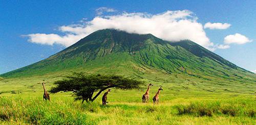
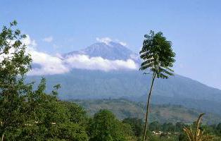
The highest mountain of the mainland - Kilimanjaro, it is located in Tanzania. The local population calls it "White Mountain", "House of God, carrying the cold." The shining whiteness of snow and the Kilimanjaro glaciers are visible hundreds of kilometers away. The dome of the mountain is formed by three peaks: central - Kibo (5696 m), eastern - Mawenzi (5149 m), western - Shira (3962 m). The East African Plateau has significant reserves of drinking water. An extensive tectonic depression is occupied by a shallow (up to 80 m) basin of Lake Victoria - the largest in the continent and the second largest freshwater body in the world. Its height above sea level is 1134 m. In this area there are other fresh water reservoirs - lakes Tanganyika, Rudolph, Eduard, alpine glaciers.
Minerals
In East Africa, crystalline structures are close to the surface, which facilitates the search, exploration and mining of metal ores, precious stones. In the composition of different
forms of relief , not only the oldest breeds prevail. There are young sedimentary and volcanic formations. The part of the continent where the East African Plateau is located is rich in igneous, metamorphic, sedimentary rocks, and minerals. The list of extracted minerals:
- iron, tin and polymetallic ores;
- noble (gold) and rare metals;
- diamond deposits:
- gemstone tanzanite ;
- coal;
- fluorite.
The diversity of nature of the East African Plateau
The climate of this region of the continent is determined by the influence of equatorial and tropical air masses that form the seasons - wet and dry. At the foot of volcanoes facing the Indian Ocean, precipitation is greater than on the western slopes. The East African Plateau is plains and plateaus dominated by savannas and light forests. Plantations of agricultural plants extend to a height of 1800 m. Typical plants are cereal grasses, shrubs, single baobabs, umbrella acacias and other trees. In the animal world of East Africa, herbivorous ungulates, predators, waterfowl predominate .

Termite buildings rise in the savannahs, snakes, lizards, and land turtles are often found. Extensive volcanic highlands and the world-famous Ngorongoro Crater (Caldar) 22 km in diameter extend to the north of Tanzania. At its bottom is Lake Magadi, the savannah of the eponymous biosphere reserve. In this part of the mainland (to the west of the Ngorongoro Crater Highlands) is located the Olduvai Gorge, where the remains of an ancient man who lived 2 million years ago, the skeletons of animals killed by him, primitive stone axes and scrapers are found.
The volcanoes and savannahs of Africa attract a large number of tourists from around the world. The largest flow of people arriving is from June to September. Large national parks and reserves have been created to study and preserve the diversity of nature, organize ecotourism on the territory of the East African Plateau.