Which river is Krasnoyarsk on? It is located on the left and right banks of the Yenisei. The size of the city according to the 2015 census is more than 1 million people. Various industries are very well developed here. This is primarily an industrial sector. It is represented by more than 17 thousand enterprises. Main directions:
- non-ferrous metallurgy;
- engineering;
- woodworking, etc.
Also here operates the largest company - OJSC "Yenisei River Shipping Company". She deals with both freight and passenger traffic.
So, what river does Krasnoyarsk stand on and what significance does it have for the city? Read the answers to these questions below.
Yenisei - a river in Siberia
Yenisei - a large full-flowing river, begins in Tuva, where the Big and Small Yenisei merge together, flows from the southern to northern borders of Russia, divides the territory into Western and Eastern Siberia. The length of the river is almost 3.5 thousand km. The city of Krasnoyarsk occupies about 25 km of the coast of this water stream.
The Evenis gave the name to the Yenisei. The local population respectfully called the Ionessi River, which translated means "big water." The Russian Cossacks who moved to Siberia changed the sound a little, and the watercourse became known as the Yenisei.
The river in Krasnoyarsk impresses with its picturesque landscapes. Its shores are very beautiful and diverse, representing almost all climatic zones of Siberia. Throughout the entire length of the watercourse, you can meet the snowy Sayan ranges, the steppes of Khakassia, the forest-covered mountains of the Yenisei Ridge, and the swampy area of Turukhansk.
The Yenisei River is one of the five longest water streams in the world. It is a powerful water transport artery. Connects the south of Siberia with the regions of the Far North. It is of great economic importance.
The regime of the river and its significance
The runoff of the Yenisei water is about 3 times greater than that of the Volga, amounting to 620 cubic meters. km The river feeds mainly due to melting snow - more than 50%. The share of rain nutrition is 37%, underground - about 15%. Water consumption at each interval varies, for example, in the Krasnoyarsk hydroelectric station, this figure is about 2.8 thousand m 3 / s, the indicator of the entire region varies within 2.9 thousand m 3 / s.
The river flowing in Krasnoyarsk plays a large role in shipping and is an important waterway. It is navigable from Sayanogorsk to its confluence with the Kara Sea, which is 3,120 km. The main cargo flow passes from Krasnoyarsk to Dudinka. Ships from the sea can climb the river to the port of Igarka.
Features of the Yenisei
The river in Krasnoyarsk has a calm measured flow, which is replaced by rifts and shivers. Throughout the channel, the nature of the watercourse is changing. A few kilometers downstream from the regional center is found Kazachinsky threshold. It is located in the Krasnoyarsk Territory, the village of Kazachinskoe (distance from the center about 200 km). There are rocky ledges and a narrowing of the river bed almost 2 times. The difference in elevation is 3.8 m, the speed of the current is 21 km / h. All this is complicated by shallow areas in the form of rifts. Not every ship is capable of overcoming this difficult stretch.
After flowing into the Yenisei powerful tributaries (Angara, Podkamennaya Tunguska, Lower Tunguska), the river becomes extremely wide. This distance reaches 15 km, the depth is 20 m.
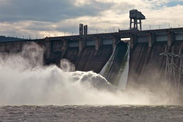
Hydroelectric power stations
The provision of the city directly depends on which river Krasnoyarsk stands on. Currently, a number of hydroelectric power stations have been built on the watercourse: Sayano-Shushenskaya, Mainskaya and Krasnoyarsk. The construction of power plants has led to serious environmental problems. For more than 500 km, ice-free wormwood is formed. Because of this, climatic conditions change, characterized by high humidity, changes in ambient temperature. Also, the formation of reservoirs entailed the flooding of fertile lands, the destruction of archeological monuments, a significant decrease in fish resources. After the flooding of the Boguchanskaya HPP began , the water level downstream dropped significantly, the banks were bare by several meters, which led to a decrease in the number of some fish species. With the commissioning of 26 nuclear reactors in Krasnoyarsk in the 1950s to produce weapons-grade plutonium with direct-flow cooling without purification, the Yenisei was exposed to radiation contamination.
After reading this article, you now know which river Krasnoyarsk is on.