From the swampy tundra of the Arctic, completely dotted with cloudberries, to the feather grass steppes of Kazakhstan for more than 2500 kilometers through the vast plains covered with taiga, a grandiose natural stone structure stretched - the Ural Mountains. On a map or from a bird's eye view, one can see how they are expanding behind the scenes of parallel ridges, then narrowing to a “narrow” strip (only 30 km), sometimes almost disappearing among the hills covered with centuries-old trees, and suddenly suddenly soar into fantastic bulks dotted with placers domes over the taiga sea. The Ural ridge is a continuous series of successive diverse natural landscapes.
Locations: Ural Mountains
This stone massif with the territories adjacent to it is customary to divide into four parts: Polar, Subpolar, Middle and Southern Urals. Each of them has its own climatic conditions, its vegetation, its own natural resources. If you look at the Ural Mountains on a map, you can see that they begin in the region of the Baydaratskaya Bay of the Arctic Ocean. The first peak of the Polar Urals is Konstantinov Kamen, its height is only 492 meters. This part of the ridge is located on the territory of the Yamalo-Nenets Autonomous Okrug and the Komi Republic. The circumpolar Urals originates from the Saber massif and further extends along the meridian of 59 ° C. w. It consists of two parallel ridges. The territory of the Subpolar Urals ends with a rather high peak (1569 m), which is called Konzhakovsky Stone. The middle part of this monumental natural structure lies between 56 and 59 degrees north latitude. Here the geographical position of the Ural Mountains is changing. The meridional strike is replaced by a southeast direction. The last, fourth, part of the Ural massif originates from Mount Jurma and extends to the Ural River. The southern tip of the ridge is the widest and reaches about 200 kilometers.
Poetic Retreat
These gray ridges, smoothed by winds and time, today can no longer impress with either the steepness or the height of the slopes, but their severe majesty fills the air with the aroma of eternity. Here, the intermountain valleys sheltered a huge number of crystal clear springs and lakes of wonderful turquoise hues. From ancient peaks, emerald streams begin their distant run to large lakes and rivers - Pechora, Ob, Kame. The slopes are overgrown with bushes and trees, which under a piercing wind frantically cling to the cracks in the dilapidated rocks - the eyes of the traveler have a delicate and fragile beauty. The remnants of a virgin forest cling to the stern and gloomy stone guards, as if asking them for protection from a person who brings death to the wild.
Natural characteristics of the Southern and Middle Urals
The nature of the southern part of the Ural Ridge is soft and welcoming. Mixed taiga covers the slopes. Cozy river valleys are inhabited by the Bashkir people, who gave the names to most of the hills and rivers. Including the summit of Yaman-Tau, which means "bad mountain". This peak of the Ural Mountains is the highest (1640 m) in these places. The middle part is the lowest of the entire Stone belt. The abundance of rivers carrying their waters among the majestic cliffs enliven the space of wooded Parma (hills), where individual peaks rise above the border of the forest, wistfully overlooking the green sea below. Here, on high ridges, you can meet both the mountain tundra and real alpine meadows.
Harsh north
Moving further north, the stone wall begins to gain height, the mountains look more severe and gloomy. It becomes clear why local residents from ancient times called them so. After all, the name "Ural" arose recently, in the 18th century, with the light hand of Tatishchev. And the people always called and continue to call these mountains Stone, or Stone Belt. Even most of the peaks of the Urals have preserved the memory of this: Kosvinsky, Denezhkin, Konzhakovsky and many other stones. These giants reach the clouds, and the peaks are hidden behind a white curtain. The description shows that the unique geographical location of the Ural Mountains incorporates various climatic and natural zones. The beauty of pristine nature cannot be expressed in words, it must be seen firsthand.

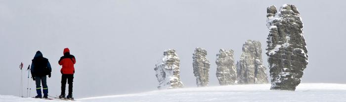
If you go further north, you can see the first punishment, snowfields and moraine ridges. Where the fast river Schugor rushes to Pechora, the giant Telpoz-Iz has risen, which means "nest of winds". This is the highest mountain of the Ural Mountains in this part of the Stone Belt, its height is 1617 m. It received its poetic name from the indigenous inhabitants - Komi-Zyryan. The nest of winds stands out from the total mass with powerful rocky cliffs, strong winds and clouds almost constantly hanging over the slopes and the first glaciers. In the 15th century, the Shchugor River passed through the Urals, and this notable peak was a guide for travelers. Russian annals eloquently called it the Pillar. In those days, it was mistakenly believed that it was the highest mountain of the Ural Mountains. Further north you can see the Saber peak (1497 m), it is clearly visible from the banks of the Pechora. In the mid-19th century, this peak also claimed primacy. And only in the 20th century did the disputes end, and it was established for certain that both of them were inferior to the mountain opened in 1927 under the name Narodnaya.
The highest peak of the Ural Mountains: the history of discovery
In the years 1924-1928. in the northern unexplored regions of the Urals, an expedition of the USSR Academy of Sciences was conducted under the leadership of B. Gorodkov. In June 1927, one of its units (and was led by geologist A. Aleshko) reached the headwaters of the Naroda River. The expedition, conducting a survey of the area, discovered a number of peaks that surpassed all previously known then in the Stone belt. The highest point of the Ural Mountains was named People’s in honor of the river, near which it is located, and the tenth anniversary of the Soviet people (more on this below). In 1929, A. Aleshkov published the report of his expedition - “Northern Urals (Lyapinsky Territory)”. This was the first publication reporting the highest peak of the Ural ridge. In addition, the author spoke about her neighbors: the peaks of Karpinsky (1780 m) and Didkovsky (1750 m). With their opening, disputes about the primacy among the mountain peaks of this region (Saber, Telpos-Iz, etc.) were ended once and for all.
Folk or Folk?
What syllable should be stressed? Scientists have long debated on this issue. Some claimed that the discoverer named it in honor of the Soviet people. Their opponents argue that this highest mountain of the Ural Mountains takes its name from the Narada River, which flows at its foot. The people translated from the Mansi language means "forest". She really originates in the forest. Meanwhile, scientists found that the indigenous people called her Poengurr. Now it is impossible to find reliable information about what the discoverer of the peak Alyoshkov had in mind. In his notes, he did not put emphasis and did not explain anything in this regard. So let us leave the debate for scientists, and we will pay attention directly to this magnificent peak. The highest mountain of the Ural Mountains allows us to admire the indescribable panorama - the chaos of the mountains, the severe, majestic and formidable region. Standing at the top of the peak, you understand that nothing has changed here, everything has remained the same, like a hundred, two hundred or even a thousand years ago. Time stands still ...

Popular tourist route
This highest mountain of the Ural Mountains and its surroundings interested fans of extreme types of recreation only in the late 50s of the last century. With the arrival of tourists, the appearance of the mountain began to change. Various tablets and commemorative signs appeared here. Tourists have a custom - to leave notes on top. And in 1998, the Orthodox Church established a worship cross here , on which is written "Save and save." In 1999, Christians went even further, they organized a procession to the highest point of the Urals.
Description of People’s Mountain
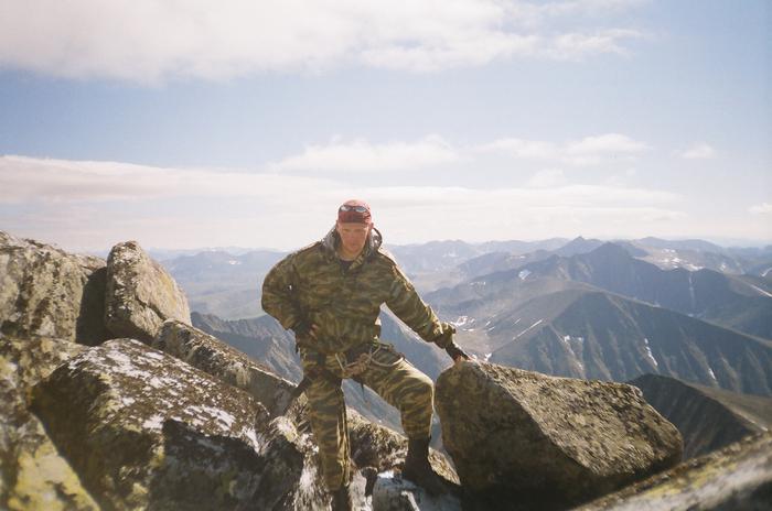
The slopes of this majestic peak are covered with punches - these are natural cup-shaped depressions that are filled with ice and clear water. In addition, there are many large stone blocks. There are snowfields and glaciers. The relief in this part of the Stone Belt is mountainous, with deep gorges and steep cliffs. Tourists must be very careful not to get injured. Moreover, the nearest housing is very, very far away. You can climb Peak Narodnaya along the western ridge, however, there are very rocky steeps and many cars, this greatly complicates the ascent. It is easier to climb the northern slope - along the spurs of the mountain. And the eastern side of the peak consists entirely of sheer walls and gorges.
Equipment
You will not need climbing equipment to climb this peak. Nevertheless, to make a trip to a deserted mountainous terrain, you should have a high-quality sports uniform. And in case of insufficient tourist experience it is best to use the services of an experienced guide. It should be borne in mind that the climate of the circumpolar Urals is very severe. Here, even in summer, cold, changeable weather reigns. It is believed that the most favorable period for a trip to this region is July and the first half of August. When going on a trip, it should be borne in mind that the trip will last at least a week. There is no housing here, you have to spend the night only in tents. Geographically, Mount Narodnaya belongs to the Khanty-Mansi Autonomous Okrug. If you are not limited in time, then you can visit another point - the top of Managar. She, of course, is lower than Narodnaya, but she will be able to surprise you with her extraordinary beauty.
How to get to the peak of Narodnaya?
First you need to get by rail to the station Upper Inta (Komi Republic). Here at ul. Dzerzhinsky, 27a is the office of the national park "Yugyd Va." Campaign participants should register and obtain permission to visit the area. You need to know that the application is submitted in advance, 10 days before the trip. Having completed all the formalities, go to the bus station, from where you get to the city of Inta. There is a hotel here where you can stay, as it will take some time before casting into the mountain area. You will need to order a car for this, which will take you to the Zhelannaya industrial base near Lake Bolbanty. And from here, on foot, 17 kilometers to the foot of the mountain along the Balbania river. That's it, the climb begins ...