Since the ships - the creations of human hands - began to plow the seas and oceans, the navigators had the task of determining their own location. Huge waves, squalls and the need to maneuver with tacks, holding the headwind, made it difficult for many days to sail, and the old-time sailors did not have enough compass. Today, when the vessel’s location is determined automatically thanks to the GLONASS satellite systems , it is difficult to imagine the position of a captain who has at his disposal only simple devices for orienting himself in the stars. Nevertheless, today graduates of specialized secondary and higher specialized educational institutions own all of these devices.
Basic methods of marine location
Two-dimensional determination of a vessel in three-dimensional space (location) is carried out by seven types of methods, including:
- The oldest is visual.
- Later, but not by much - astronomical.
- Topographic-computational, that is, a method of plotting the full path of a ship with an indication of the course change points and calculating the distance traveled by multiplying speed by time. Invented at about the same time as the astronomical method, and is often used in conjunction with the two previous ones. Today, routine work is done by automatic numerators;
- Radar, allowing you to combine the picture on the screen of the radar with a nautical chart.
- Radio direction finding. Available when there are signal sources on shore.
- Radio navigation, using communication means by which the navigator receives the information he needs.
- Satellite navigation method.
All methods, except the first three, were the result of a technological revolution that occurred in the 20th century. They would not have been possible without the discoveries and inventions made by mankind in the field of radio engineering, electronics, cybernetics and a breakthrough in the space sphere. Now it’s not difficult to calculate the point in the ocean where the ship is located, determining its coordinates takes a matter of seconds, and, as a rule, they are tracked continuously. Approximately the same technologies are used in aviation navigation and even in such a “mundane” area as car driving.
Latitude
As you know, the earth is not flat, it has the shape of a somewhat flattened ball. The points on the three-dimensional figure, it would seem, should be described by three Euclidean coordinates, but two are enough for geographers and navigators. In order to make a topographic definition of a ship, you need to name only two numbers, accompanied by the words “north” (or “south”) latitude (abbreviated north or south latitude) and west or “east” longitude (otherwise - z. D. or E). These values are measured in degrees. Everything is very simple. Latitudes are calculated from the equator (0 °) to the poles (90 °), indicating which direction: if closer to Antarctica, then the southern latitude is indicated, and if to the Arctic, then northern. Points of the same latitude form circles called parallels. Each of them has a different diameter - from the largest at the equator (about 40 thousand kilometers) to zero at the pole.
Longitude and length measures
It is not possible to determine the position of a vessel by one coordinate, therefore there is a second. Longitude is a conditional meridian number, again indicating the side to which the reference is being taken. The circle is divided by 360 °, its two halves, respectively, are 180. The Greenwich Meridian, passing through the famous British observatory, is considered to be zero. On the other side of the planet is its antipode - the 180th. Both of these coordinates (0 ° and 180 °) are indicated without a name for the direction of longitude.
In addition to degrees, there are also minutes - they indicate the position of objects with 60 times greater accuracy. Since all meridians are of equal length, they became the measure of length for sailors. One mile (nautical) corresponds to one minute of any meridian and is equal to 1.852 km. The metric system was introduced much later, so ship navigators use the good old English mile. Also applicable are units such as cables - it is 1/10 of a mile. What is surprising, because before the British more often considered dozens than dozens.
Visual way
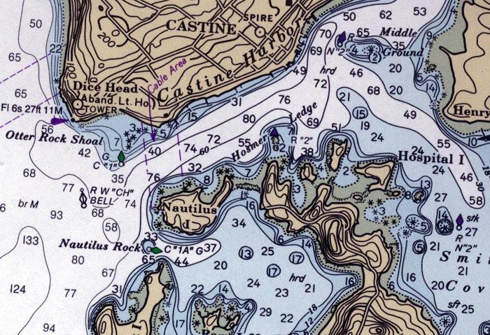
As the name implies, the method is based on what the navigator and the captain see, as well as other team members on deck or gear. Earlier, in the days of sailing fleets, there was a position ahead of the beholder, the post of this sailor was located at the very top, in a specially fenced-off place of the main mast - klotik. From there it was better to see. Determining a ship’s location on coastal objects is similar to the simplest method of a pedestrian who knows that he needs, for example, a house on Staroportofrankovskaya street at number 12, and for accuracy there is another search criterion - a pharmacy located opposite. True, other objects serve as landmarks for sailors: lighthouses, mountains, islands, or some other noticeable landscape details, but the principle is the same. It is necessary to measure two or more azimuths (this is the angle between the compass needle and the direction to the landmark), plot them on the map and get their coordinates at the intersection point. Of course, such a geographical definition of a ship, or rather its location, is applicable only in the zone of coastal visibility, and even in clear weather. In the fog, you can navigate by the sound of the lighthouse siren, and for lack of surface signs, you can turn to shoals in shallow water, measuring the depth with a lot.
Maritime Astronomy
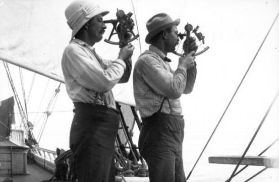
The most romantic location method. Around the 18th century, sailors, along with astronomers, invented the sextant (sometimes called the sextant, that’s also right) - a device with which you can make a fairly accurate two-coordinate determination of the ship according to the position of the stars in the sky. Its device at first glance is complicated, but in fact, you can learn how to use it quite quickly. In its design there is an optical system, which should be pointed at the Sun or any star, after installing the device strictly horizontally. For precise guidance, two mirrors (large and small) are provided, and the angular elevation of the star is determined by the scales. The direction of the device is set by the compass.
The creators of the device took into account the centuries-old experience of ancient navigators, focusing only on the light of stars, the moon and the sun, but created a system that simplifies both navigation training and the location process itself.
Calculation
Knowing the coordinates of the starting point (exit port), travel time and speed, you can plot the entire path on the map, noting when and how many degrees the course was changed. This method could be ideal when the direction and speed are independent of the current and wind. The uneven course and errors of the lag indicator (speed meter) also affect the accuracy of the coordinates obtained. The navigator has a special ruler for laying parallel lines on the map. The determination of the maneuvering elements of a marine vessel is made using a compass. Usually, the true position is determined at the point of change of direction using other available methods, and since it, as a rule, does not coincide with the calculated one, a peculiar squiggle is drawn between the two points, which vaguely resembles a snail and is called a "residual".
Currently, on board most ships, automatic calculating devices are installed, which, taking into account the entered speed and direction, integrate over a variable time.
Using radar
Now there are no white spots on the sea charts, and an experienced navigator, seeing the outlines of the coast, can immediately tell where the boat entrusted to his care is located. For example, noticing the light of a lighthouse on the horizon even in the fog and hearing the muffled sound of his siren, he will immediately say something like: "We are on the traverse of the Vorontsovsky fire, two miles away." This means that the vessel is at a specified distance on a line connecting at right angles to the course and the perpendicular direction to the beacon, whose coordinates are known.
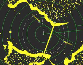
But it often happens that the coast is far away, and there are no visible landmarks. Previously, during the sailing fleet, the ship was “drifted”, collecting sails, sometimes if the capricious nature of the dominant winds and the unpredictability of the bottom (reefs, shallows, etc.) were known, they anchored and “waited in the sea of weather ”, That is, clarifications. Now there is no need for such a loss of time, and the navigator can see the coastline by looking at the locator screen. The definition of a ship using radar is a simple task with qualifications. It is enough to combine the image on the navigation device and the map of the corresponding area, and immediately everything will become clear.
Direction finding and radio navigation method
There is such a radio amateur game - “Fox Hunting”. With the help of home-made appliances, its participants look for a fox hiding in the bushes or behind trees - a player who has a working radio station of low power. In the same way, that is, direction finding, counterintelligence services calculate residents of foreign intelligence (at least, it used to be) at the time they sent espionage reports. A location requires at least two directions that intersect at a location point, but more often there are more. Since there are always some scatter of readings, and it is impossible to achieve absolute accuracy, the bearings do not converge at one point, but form a kind of multilateral figure, in the geometric center of which it is highly likely to assume its location. Reference points can be specially created pilot signals on the shore (for example, on lighthouses) or radiation from radio stations whose coordinates are known (they are mapped).
Coastal course corrections using radio communications are also widely applicable.
By satellites
Today, getting lost in the ocean or sea is almost impossible. The movement of moving objects at sea, in air and on land is monitored by navigation and rescue systems, the Russian Cospas and the international Sarsat. They work on the Doppler principle. It is necessary to install a special beacon on the ship, but safety and confidence in the successful outcome of the voyage are worth the money spent on it. Direction finders are located on the geostationary (“hanging” over a fixed point on the earth's surface) satellites that make up the system. This service is provided free of charge and, in addition to the rescue function, performs a navigational search for the location of the vessel. The satellite-navigation method gives the most accurate coordinates, its use is straightforward, and navigators use it most often in our technological age.
Additional parameter - loading
The ship's navigability and its possible course are significantly affected by its draft. As a rule, the larger the body part immersed in water, the higher the level of its hydrodynamic resistance. There are, however, exceptions, for example, in atomic submarines the underwater passage exceeds the surface, and a special nasal "bulb" in the event of its complete drowning creates the effect of better streamlining. One way or another, but the speed of movement (stroke) is affected by the mass of cargo (cargo) in the holds or tanks. To assess this value, sailors use special tags with risks on the bow, stern and side of the hull (scales of at least six). These signs are applied individually, each vessel has its own, there is no single standard. The methodology for determining the weight of cargo on board the vessel, called the “draft survey”, is based on the use of “draft marks” and is used for many purposes, in particular navigation. The depth of the bottom does not always allow the ship to go along a specific channel, and the navigator must take this factor into account.
It remains only to wish at least seven feet under the keel to those who set sail.