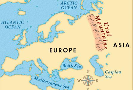
It is generally accepted that the border between Asia and Europe runs along the Ural mountain range, the coast of the Caspian Sea and a number of straits and rivers. The length of this path is about 6 thousand kilometers.
There is an alternative option, according to which the border is drawn along the watershed of the Ural Territory and the Caucasus. To find out which version is true, a historical, geographical overview of the continent will help.
Early views
Since ancient times, people have been asking questions about where the earth ends, what constitute parts of the world. About 3 millennia ago, the land was first conditionally divided into 3 areas: West, East and Africa.
The ancient Greeks believed that the border between Asia and Europe runs along the Black Sea. At that time it was called Pontus. The Romans moved the border to the Sea of Azov. In their opinion, the division went along the Meotida water area, including the Kerch Strait between Europe and Asia and the Don River.
In their writings, Polybius, Herodotus, Pomponius, Ptolemy and Strabo wrote that the border between parts of the world should historically be drawn along the coast of the Sea of Azov, smoothly transitioning to the Don channel. Such judgments remained true until the 18th century AD. Similar findings were presented by Russian theologians in the book Cosmography, dating from the 17th century. Nevertheless, in 1759 M. Lomonosov concluded that the border between Asia and Europe should be drawn along the Don, Volga, and Pechora rivers.
Representations of 18-19 centuries
Gradually, the concepts of the separation of the parts of the world began to take shape. In medieval Arabic chronicles, the waters of the Kama and Volga rivers were listed as border. The French believed that the dividing line runs along the Ob channel.
In 1730, the Swedish scientist Stralenberg put forward a proposal to draw a border along the Ural Mountains basin. An identical theory a little earlier in his authorial works was identified by the Russian theologian V. Tatishchev. He refuted the idea of dividing parts of the world only along the rivers of the Russian Empire. In his opinion, the border between Asia and Europe should be drawn from the Great Belt to the coast of the Caspian Sea and Tauris Mountains. Thus, both theories converged in one thing - the separation runs along the water area of the Ural Range.
For some time, the ideas of Stralenberg and Tatishchev were ignored. At the end of the 18th century, the recognition of the authenticity of their judgments was reflected in the writings of Polunin, Falk, Shchurovsky. The only thing the scientists did not agree on was to draw the Miass border.
Back in the 1790s, the geographer Pallas proposed limiting the division of the Volga, General Syrt, Manych and Ergeni rivers to the southern slopes. Because of this, the Caspian lowland belonged to Asia. At the beginning of the 19th century, the border was again pushed a little to the west - to the Emba River.
Confirmation of theories
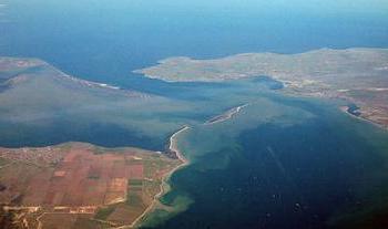
In the spring of 2010, the Russian Society of Geographers organized a large-scale expedition to the territory of Kazakhstan. The purpose of the campaign was to revise general political views on the line of separation of the parts of the world - the mountain range (see photo below). The border of Europe and Asia was supposed to pass along the southern part of the Ural Upland. As a result of the expedition, scientists determined that the separation is a little further from Chrysostom. Further, the Ural Range disintegrated and lost its pronounced axis. In this area, the mountains are divided into several parallels.
A dilemma arose between scientists: which of the decayed ridges is considered the boundary of the parts of the world. During a further expedition, it was found that the correct separation should take place along the banks of the Emba and Ural rivers. Only they are able to clearly represent the true borders of the mainland.
Another version was the establishment of the axis of division along the eastern isthmus of the Caspian lowland. The reports of Russian scientists were taken into account, but they did not wait for consideration by the International Union.
Modern border
For a long time, political views did not allow European and Asian powers to agree on the final separation of the parts of the world. Nevertheless, at the end of the 20th century, the definition of the official border still took place. Both sides proceeded from cultural and historical concepts.
Today, the axis of division of Europe and Asia goes through the Aegean, Marmara, Black and Caspian Seas, the Bosphorus and Dardanelles, the Urals up to the Arctic Ocean. Such a border is represented in the international geographical atlas. Thus, the Urals is the only river between Europe and Asia through which separation passes.
According to the official version, Azerbaijan and Georgia are partially located in both parts of the world. Istanbul is a transcontinental city at all because of the Bosphorus Strait belonging to both Asia and Europe. A similar situation is with the whole country of Turkey. It is noteworthy that the city of Rostov also belongs to Asia, although it is located in Russia.
Exact division in the Urals
The question of the boundary axis between parts of the world unexpectedly opened an active discussion among the residents and authorities of Yekaterinburg. The fact is that this city between Europe and Asia is currently located several tens of kilometers from the conditional division zone. Given the rapid territorial growth, Yekaterinburg in the coming years may inherit the fate of Istanbul, becoming transcontinental. It is noteworthy that a memorial has already been erected 17 km from the Novo-Moscow highway, showing the border of the parts of the world.
The situation in the vicinity of the city is much more interesting. There are large water areas, and mountain ranges, and settlements. At the moment, the border passes through the watershed of the Middle Urals, so for now these areas remain in Europe. This applies to Novouralsk, and the mountains Kotel, Birch, Varnachya, Khrastalnaya, and
Lake Chusovskoye. This fact casts doubt on the correctness of the construction of a border memorial on the Novo-Moscow tract.
Transcontinental states
Today, Russia is the largest country on the border territory between Europe and Asia. Such information was announced at the end of the 20th century at the UN summit. There are five transcontinental states, including the Russian Federation.
Of the rest, Kazakhstan should be distinguished. This country is neither a member of the Council of Europe nor an Asian counterpart. Republic with an area of 2.7 million square meters. km and a population of about 17.5 million people have intercontinental status. Today it is a member of the Eurasian Community.
The jurisdiction of the Council of Europe includes such border countries as Armenia and Cyprus, as well as Turkey, Georgia and Azerbaijan. Relations with Russia are defined only within the framework of the agreed regulation.
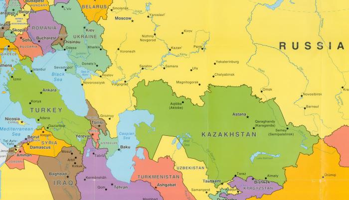
All of these states are considered transcontinental. Standing out among them is Turkey. It occupies only 783 thousand square meters. km, however, is one of the most important trade and strategic centers of Eurasia. Representatives of NATO and the European Union are still fighting for influence in this region. The population here is over 81 million people. Turkey has access directly to four seas: the Mediterranean, Black, Marmara and Aegean. It borders with 8 countries, including Greece, Syria and Bulgaria.
Transcontinental bridges
In total, over $ 1.5 billion was spent on all structures. The main bridge between Asia and Europe lies across the Bosphorus. Its length is more than 1.5 kilometers with a width of 33 m. The Bosphorus Bridge is suspended, that is, the main mounts are located on top, and the structure itself has the shape of an arc. The height at the center point is 165 meters.
The bridge is not picturesque, however, it is considered the main intercontinental symbol of Istanbul. The authorities spent about $ 200 million on construction. It is worth noting that pedestrians are strictly forbidden to climb the bridge to exclude cases of suicide. The fare for transport is paid.
Border bridges in Orenburg and Rostov can also be distinguished.
Transcontinental commemorative signs
Most of the obelisks are in the Urals, Kazakhstan and Istanbul. Of these, a memorial sign at the Yugorsky Shar Strait should be highlighted. It is located on the island of Vaigach and is the northernmost point of the border between Europe and Asia.
The extreme eastern coordinates of the transcontinental axis are marked with a sign in the upper reaches of the Malaya Shchuchya River.
Among the obelisks, monuments can be distinguished near the village of Promysl, at the Uralsky ridge station, at the Sinegorsky pass, on the Kotel mountain, in Magnitogorsk, etc.