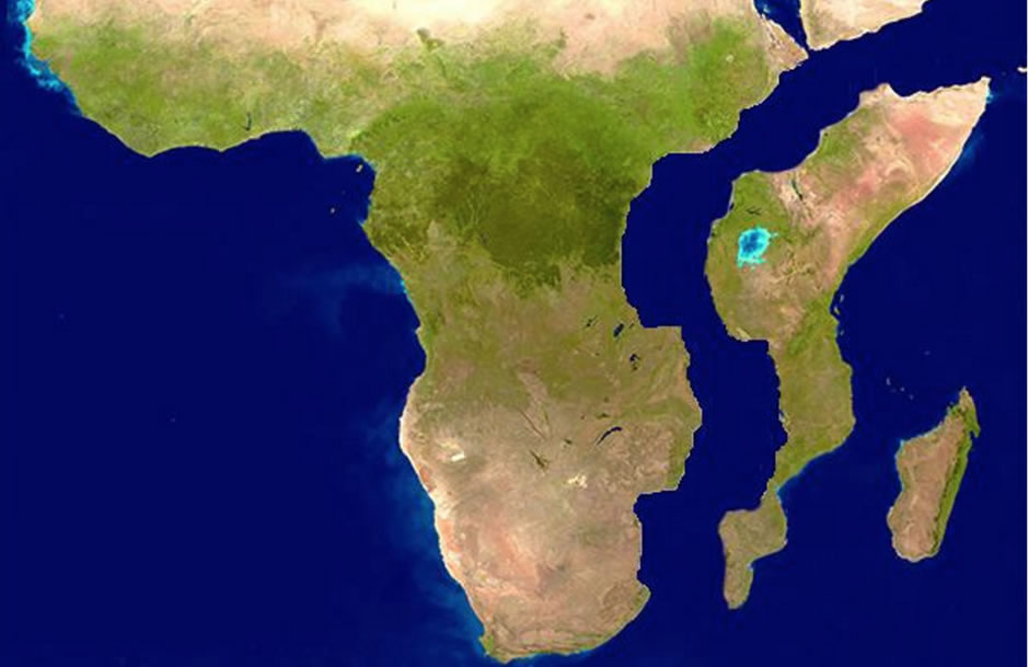
The rift valley in East Africa is a huge geological fault in the earth's crust. Passes through northern Ethiopia to the central part of Mozambique. The rift valley begins in the Ethiopian Highlands and stretches along the meridian of thousands of kilometers, while dividing into branches (total length more than 9000 km). The width is up to 200 kilometers, and the depth of this huge fault varies from several hundred meters to a kilometer.
Research history
First discovered the Great African Rift Valley at the end of the 19th century. At present, it can be clearly seen from space.
The name she received from the English geologist John Walter Gregory, who studied East Africa and Australia. In the same places, fossilized remains of hominids were found (a family of the most developed primates, including humans).
Geology
The rift valley was formed in the Oligocene-Quaternary as a result of a series of shifts in the earth's crust accompanied by intense volcanic activity due to the displacement of lithospheric plates (African and Arabian). It consists of two branches, the eastern one (Gregory Rift) stretches north of Lake Victoria and goes to the depression of the Red Sea.
Along the way, it passes through Tanzania and Kenya. The second western branch is shorter - Albertin Rift. The northern part of the fault turned into the Red Sea, filled with water, each year this depression is gradually widening due to the continuous formation of the oceanic crust.
What is a rift?
Most correctly, the rift valley can be called a system of East African rifts. The rift is a huge elongated hollow in the earth’s crust that occurs at the rupture of the earth’s crust when tensile forces or longitudinal displacements of two plates act on it. Such a cleft can form on land and in the ocean. There are areas in the rift system where oceanic crust can form. An example of this phenomenon in the Great Rift Valley is the Afar Depression, located in its northern part.
Afar Valley
This is a deep depression, which has dropped to 150 meters below sea level as a result of geological processes. This land area is also called the “Afar Triangle”, since the intercontinental rifts of the Gulf of Aden and the Red Sea are connected with the system of continental East African rifts. The relief and climate contributed to the creation of one of the hottest places on the planet. The average minimum temperature is + 25 degrees, and the maximum +35, the annual rainfall is 200 millimeters. The Afar Basin is about two million years old; it formed in the Quaternary. Volcanoes rise on the Afar border, some of them active.
The volcano Dabbahu has a height of 1442 meters, it is known for its eruption in 2005. Before the volcano awakened, earthquakes occurred, resulting in a large crack in the earth's crust. It is called the Dabbahu Fault. Scientists believe that this same fault precedes the beginning of the separation of the Somali plate from the African. Thus, Africa will be divided in two in the future. Afar Valley - second place, after Ireland, where you can study the oceanic crust directly on land.
Another hollow is also famous for its volcano - Erta Ape. This is a shield volcano that has been continuously active since 1976, it is the only one on the planet that has two lava lakes.
Volcanoes of the Great Rift Valley
In the eastern branch of the valley is the highest volcano in Africa - Kilimanjaro, which is at the same time the highest point of the mainland. It is potentially active, gas emissions are observed, and there is an opinion that the cone may collapse, which will lead to a very large eruption. At the top of Kilimanjaro, magma is very close to the surface.
The volcanic caldera of Ngorongoro emerged after the destruction of a huge volcano 2.5 million years ago. The diameter of its crater ranges from 17 to 21 kilometers. Its depth is 610 meters, the total area is 265 square kilometers. There are many other volcanoes in the Great Rift Valley, the highest: Elgon, Kilimanjaro and Kenya. Even a National Park dedicated to volcanoes has been created; it is located in the northwestern part of Rwanda. There are volcanoes of Sabinho, Gaching, Muhabura, Bisque, Carisimbi.
Great Lakes of Africa
The rift valley passes through the lakes of Africa, among them there are large ones - Victoria, Nyasa, Tanganyika. And smaller bodies of water.
Southwest of the Afar Basin , a whole chain of lakes formed in the rift zone: Abaya, Zvay, Shala, Chamo.
Lake Rudolph was formed at the site of the trough of the earth's crust between the Kenyan and Ethiopian vaults. Here is the Rudolph rift of the same name with the lake.
Tanganyika is the world's longest freshwater lake. Its length is 700 kilometers. It belongs to the western branch of the rift valley, as well as the lakes - Albert, Kivu, Rukva, Eduard.
Lake Victoria is the largest in Africa and the second largest freshwater lake on the planet after the Upper (in North America).
Nyasa. In the area of this lake, the eastern and western branches of the Great Rift Valley are connected and go to the Indian Ocean.