Tolyatti appeared on the map of Russia not so long ago - in 1964, but in fact the city founded by Vasily Tatishchev will be 280 years old next year. Since 1737, it was called Stavropol-on-Volga. Its history is unique: once in the flood zone during the construction of the Zhigulevskaya hydroelectric station (1953–1955), it completely changed its location. Where he is today and what he is, you can find out by reading this article.
Middle Volga
As part of the Volga Federal District , its southern part, called the Middle Volga, stands out. On both sides of the longest river in Europe are the Penza, Ulyanovsk, Saratov and Samara regions, as well as the Republic of Tatarstan. It is here that Togliatti is located. What area sheltered a modern industrial city on the left bank of the Volga? Despite the 18th place in the country in terms of population (more than 712 thousand people) and occupied area (more than 315 square kilometers), Togliatti is not a regional administrative center.
The Middle Volga region is a densely populated and economically developed territory with a favorable geographical position and developed infrastructure. Convenient transport interchanges favorably affect the development of the engineering, oil refining, gas and chemical industries, which the region is famous for. 74% of the population live in cities. The territory is located in the zone of temperate continental climate, where hot summers (+25 ° ) and low snowy winters with minus temperatures (average values are 12-15 degrees below zero) are clearly distinguished. But there are frosts up to -30 ° C. The border with the Lower Volga region runs along the Zhigulevskaya hydroelectric station, where Togliatti is located.
What region does the Volga city include?
The Samara region, bordering Tatarstan, the Orenburg, Ulyanovsk and Saratov regions, is located in the southeast of the East European Plain. It consists of 11 cities and 23 villages united in 27 districts. Tolyatti is the administrative center of the Stavropol region in the north-west of the region, 59 km away from the regional capital. The distance between cities along the highway is 88 km and is covered in about 2 hours. The residents of the region do not have a question about how to get to Togliatti, where a magnificent recreation area is located. Shuttle buses run every half hour from all stations of the city.
Located at the junction of three zones - forest-steppe, steppe and forest - Samara region has a forest cover of only 12.6%. Broad-leaved trees are located in the north of the region, including in the Stavropol region, where residents of the regional capital rush during the vacation period.
Samara Luka
The Samara region is located in the middle reaches of the Volga River, where the length of the coastline of 230 km formed the largest bend (meander), called Samara Luka. It stretches for 60 km from west to east and 30 km from north to south, from the village of Usolye to the city of Syzran. In fact, Samara Luka is washed by the waters of two reservoirs - Saratov and Kuibyshevsky - and the small river Usa. The answer to the question about Tolyatti: "What area has it in its composition?" - Most Russians know it precisely because the city is located on the banks of the Kuibyshev reservoir. Kuibyshev is the name of the city of Samara until 1991.

The most picturesque section of Samarskaya Luka is the distance from Samara to the locks of the Zhigulevskaya hydroelectric station, the crown of which are the Zhiguli mountains (height - 375 meters). The river in this place is not wide, and tourists can clearly see how the hill steeply breaks off towards the Volga. Hydroelectric power stations and mountains are located on the right bank of the river, where the city of Zhigulevsk is located. On the left, at the junction of the low-lying and forest-steppe Volga region and Samara Luke, Tolyatti extends (a photo of the city and Samara Luke is presented in the article).
Geographical position
It is located 70 km higher along the Volga River relative to the capital of the Samara region. The length of the borders is 149 km. The city is not part of the Stavropol region and, in addition to it, borders on Zhigulevsk. For a long time, the question of connecting these two cities has been discussed, but so far this is only a project. From the south, the city merges with the dam of the Kuibyshev reservoir, from the east it is surrounded by forests, and from the north-west - agricultural land.
Togliatti on the map of Russia can be found by the following coordinates:
- 53 ° 31 'North;
- 49 ° 25 'East.
The city is in the Samara time zone. Its shift relative to Moscow time is +1 hour. The region has summer time, which leads to a shift relative to UTC.
A bit of history
06/20/1737, after the return of the Orenburg expedition led by Tatishchev, Anna Ioannovna granted a letter of founding of the city to Princess Anna Taishina for the construction of a fortress in order to collect all the baptized Kalmyks on this site. This date is considered the day the settlement was founded. There is an opinion that throughout the history of the city of Togliatti was born three times. What area at that time existed on the site of Samara? In the 50s (moving from a flooded lowland), the city was part of the Kuibyshev region, which launched the construction of a hydroelectric station named after Lenin (the old name is Zhigulevskaya). The created base of grandiose construction was later used to establish chemical enterprises (KuibyshevAzot, TogliattiKauchuk, TogliattiAzot) and the Volga Automobile Plant. The decision to build AvtoVAZ was the third birthday of the city, because it caused a huge influx of young people and contributed to a significant population growth.

In 1964, by decision of the federal authorities, the city of Stavropol was renamed Togliatti in honor of Palmiro Togliatti, who headed the Italian Communist Party. He died the day before, while in the USSR. The Italian politician had nothing to do with the city that bears his name for 82 years, so the question of returning the original name is widely discussed by the public.
Territory, administrative structure
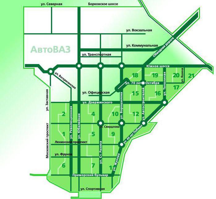
Today Togliatti, a photo of which you can see on the page, covers an area of about 315 square meters. km, 25.5% of it is urban forest. This is the greenest city in the Samara region. Between its three administrative regions, stretched along the Volga for 40 km, there are significant distances. 36% of the city territory is occupied by the Avtozavodsky district, where AvtoVAZ squares are located. It is separated from the Central 3 km of forests. The Komsomol district is removed 5-7 km further. By area, it, like Central, occupies 32% of the entire territory of the city.
Since its foundation, the city has its coat of arms in the form of a fortress with a cross in the middle. The mayor is the head of the executive branch; today, S. I. Andreev is in this position. Legislative power is concentrated in the hands of the Togliatti City Council, consisting of 35 deputies. In October 2015, Togliatti (Samara Region) received the status of a single-industry town, since the social welfare of most residents depends on the situation at the region’s main enterprise, AvtoVAZ.
Avtozavodsky district
Between themselves, residents distinguish the territory of the New and Old Towns. The first includes the Avtozavodsky district, whose population significantly exceeds the total number in the other two and makes up more than 436 thousand inhabitants. It occupies the western part of the city, overlooking the banks of the Volga. In its structure, it is divided into 28 quarters, within which parks and boulevards are divided. The main roads separate the quarters. But such a development is not typical for the whole of Togliatti, the map of which gives an idea of the features of each administrative district. In addition to AvtoVAZ, on the territory of the New City there are light industry enterprises known in the region: a champagne wine factory, a dairy and a clothing factory.
This is the youngest district, the housing stock of which began to be erected simultaneously with the construction of an automobile plant. And the only one where the birth rate exceeds the mortality rate. New houses are being built right in the forest zone, expanding the boundaries of the city.
Komsomolsky district
About 120 thousand people live in the easternmost region, located directly on the banks of the Volga downstream. It is adjacent to the dam of the Zhigulevskaya hydroelectric station and goes directly to the federal highway M5. It is here that the city's river port is located, where tourists traveling along the Volga stop. The most beautiful embankment is the real pride of the region, whose production enterprises are located at a considerable distance from residential buildings: TogliattiAzot, AvtoVAZagregat, VAZINTERSERVICE.

Previously, the village of Kuneevka was located in the district, so for a long time the private sector and buildings of the 50s have been preserved. Despite the excellent location of the area, real estate is not in great demand. Residents prefer to spend from 20 to 60 minutes on the road, but live in more comfortable houses. This part of Tolyatti (a city map gives an idea of the area) refers to the historical values of the metropolis. Here are the temples of the XIX century: St. Tikhon and Annunciation Skete. The Shlyuzova microdistrict (former village) is called mini-Petersburg due to the buildings in the style of classicism.
central District
The name itself suggests that the location of the district is the central part of the city, where about 160 thousand inhabitants live. It is he who is unofficially called the Old City, which indicates primarily the state of the housing stock. Houses here were built during the reign of Khrushchev and Stalin. A map of Tolyatti with streets clearly demonstrates that the building principle is different from the “square-nested” one in Avtozavodsky district. In the center there is a park with urban status, and a central square from which streets go to radii to different ends of the district with radii, although the system of names by quarters is preserved.

Residents of the Old Town in everyday life are considered more intelligent and compared with residents of the city on the Neva River, different from Muscovites. The private sector is significantly represented here, where class stratification is evident. Along with small dilapidated houses, elite cottages are being built, guarded by a pack of dogs. The Portovy microdistrict is located on the Volga coast, considered to be a real paradise town in Tolyatti (Samara region).
Population
The city is rightly considered to be young, because its population is young. According to the latest census, the average age of Togliatti people slightly exceeds 39 years (39.2). To detain youth, more than 20 higher educational institutions were opened in the city, although in Soviet times there was only the Togliatti Polytechnic Institute and a military school (now the Military Technical Institute). The main population is people of working age, only 150 thousand people are pensioners. The nineties went down in the history of the city with sad events: the growth of drug addiction and HIV infection among young people. Today the situation has stabilized somewhat.
More than half of the inhabitants are women. Tolyatti, whose city map does not give an idea of the national composition of the population, is 83.2% populated by Russians. Among other nationalities - Tatars, Ukrainians, Mordovians, Chuvashs.
Sights. How to get there
The city attracts tourists due to the proximity of the Zhiguli Mountains. Every year, on the first Sunday of July, in the vicinity of Tolyatti, lovers of the author’s song gather at the Grushinsky festival (the new name is “Platform”). Hundreds of thousands of participants come to Mastryukovsky Lakes, where in memory of the deceased Valery Grushin songs of talented performers from all over Russia are heard. Therefore, many have the question: "Where is Togliatti, what region of Russia organizes a bard song festival?"
The most convenient way to get to the city is by air. Kurumoch International Airport is a 50 km drive, with shuttle buses and taxis. It is important to decide which part of the city a person needs to go to: New or Old, because these are completely different routes. In the summer, it is easy to get to the city by water, taking an exciting walk along the Volga. You can also get there by rail, but the main railway junction is not in Togliatti. The map will help determine the train to Samara, the capital of the region, from where there are regular buses, intercity minibuses and taxis.