As you know, the earth's crust is rather heterogeneous in its structure. Some sites are still subject to the influence of endogenous processes, while others have long been in complete rest. But do not forget that tectonic movements will constantly subject the Earth's surface to changes, and especially the most vulnerable sections of the crust - geosynclines. These areas are very mobile and have little power, unlike platforms. What are geosynclines? Let's take a closer look at this term in terms of geography.
Geosynclines in geography: definition and general description
What is geosynclinal in geography? The definition will look as follows: a large, elongated region, which has been subjected to deformation and immersion for a rather long time, as a result of which a rather impressive layer of sedimentary and volcanogenic rocks has accumulated in it. These are very plastic and mobile sections of the earth's crust, which undergo significant changes throughout the tectonic cycle.
Types of geosynclines
Two types of geosynclines are distinguished depending on the tectonic conditions of the formation and structure of the sedimentary layer. The developing sequence of tectonic events leads to deformation of the surface of these areas and the formation of both positive and negative relief forms:
- Myogeosynclinal. This form is usually formed on a shallow shelf, in those places where the earth's punishment is the most delicate and vulnerable. Under the action of large loads, it does not break, but bends, all thanks to the plastic structure of the constituent rocks. A depression forms at the deflection site, which, like a funnel, attracts sedimentary material. An increase in the mass of sedimentary deposits leads to a further decrease in the level of the depression, and this, in turn, provokes the accumulation of huge thicknesses of sediments, which lie on top of each other in layers. The composition of the deposits is quite typical. These are mainly sand, silt, carbonate sediments and silts. Gradually, after millions of years and under the influence of critical pressure, all these deposits are transformed into sedimentary rocks: schists, limestones, and sandstone.
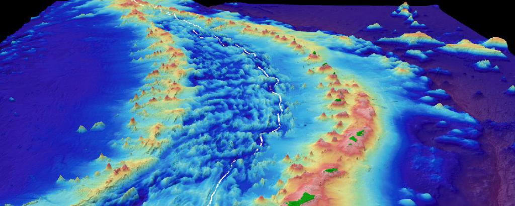
- Evgeosinklinali. Often tectonic conditions, in which sedimentation usually occurs, are sharply violated. Most often this happens in places converging (towards each other) moving plates. So, the oceanic plate can approach the mainland, and all this happens at the very base of the continental slope. In these places, the boundary usually lies between the shelf and the deeper part of the ocean. If a sharp fluctuation of the earth's crust occurs within this zone, then subduction (lowering) of the oceanic plate under the mainland will occur, and this will lead to the formation of a deep-sea trench. As myogeosynclines, they are not confined to the shelf zone and can be located anywhere on the ocean floor. But mainly these are island arcs, archipelagos with active volcanoes, and continental coasts with increased seismic activity. Intensive accumulation of sediments also occurs in gutters, but unlike myogeosingkinali, they are of endogenous origin (formed as a result of volcanic activity). A few sedimentary and clastic deposits have a very coarse structure and are interspersed with layers of basalts that poured out as a result of underwater eruptions. Constantly ongoing subduction draws these deposits into the very depths of the mantle, where, under the influence of huge temperatures and pressure, they are metamorphosed into amphibolites and gneisses.
Internal structure of mobile belts
The structure of the geosynclinal is extremely complex. After all, it is a cunning plexus of completely heterogeneous structural elements. Everything is intertwined together: island arcs, sections of the oceanic bed, parts of the coastal marginal seas, fragments of continents and oceanic uplifts. But we can clearly distinguish three components:
- Marginal deflection. It is located at the junction of folded areas and platforms.
- Peripheral zone. It is formed as a result of amalgamation of oceanic plateaus, island arcs and underwater ridges.
- Zone of orogenesis. Places where mountain building processes are constantly taking place, mainly due to the collision of continental and oceanic blocks.
A bit of geology: rocks composing geosynclinal regions
In a simple sense, geosynclines are huge troughs that are filled with all kinds of rocks. It is worth noting that the constituent material has a very heterogeneous structure. Powerful bodies of igneous, sedimentary, and even metamorphic rocks are found in geosynclinal deposits. Gradually, they are all involved in the ongoing folding processes and mountain building. The most common geosynclinal formations:
- volcanic siliceous;
- flysch;
- green stone;
- clay-shale;
- mollaceous (mainly oceanic);
Also often the presence of intrusions - atypical inclusions in the bulk of the rocks. Most often these are granite and ophiolite formations.
The evolution of geosynclines: the main stages of development
Now consider the evolution of geosynclines and the stages of their development. There are 4 stages in one tectonic cycle:
- First stage. At the very beginning, the geosynclinal is a shallow trough with single relief formations. Then there is a further lowering of the earth's crust, and the basin is filled with sedimentary material, which is brought in by riverbeds and currents. The complexity of the geosynclinal structure also gradually occurs.
- Second stage. The area begins to divide into deflections and uplifts; the relief is much more complicated. Under the weight of the sedimentary strata, crustal faults and displacements can appear.
- Third stage. Deflection is replaced by uplift. The amount of accumulated material is so large that a positive landform begins to form from the geosyncline.
- The fourth stage. Exogenous processes are replaced by endogenous. At the final stage, tectonic processes in the earth's crust play a large role. They provoke the transformation of the constituent rocks and turn the geosynclinal into a folded-block region.
Geosynclinal regions of our planet
As we remember, geosynclines are areas that are constantly in motion and are subject to deformation. These factors significantly influenced the dispersion of zones on the Earth's surface. Usually they are located between ancient platforms or between the mainland crust and the oceanic. In these zones, marginal seas, gutters, island arcs and archipelagos are most often found. The length of the geosynclinal zones can extend to tens or even hundreds of thousands of kilometers, circling the Earth's step with arcs and belts.
Outdated Geological Theory
The modern theory of plate tectonics has long been preceded by the geosynclinal hypothesis. It received its wide development at the end of the 19th century and was relevant until the 60s of the 20th century. Even in that distant time, scientists were able to determine that the deep subsidence of the earth's crust is the basis for active mountain-building processes. It was believed that the reason lies in the activation of the endogenous forces of the Earth, which launched a new cycle under the influence of the pressure of accumulated sedimentary material. Later it turned out that everything depends on the tectonic movement of the plates, and the hypothesis is outdated.
Fundamental differences of geosynclines and platforms
It is believed that geosynclines are the most active parts of the Earth's crust. They are more unstable and mobile, unlike platforms, which, in turn, are relatively stable. Geosynclines are located on the periphery of tectonic plates, in places of their frequent collision, and therefore occupy thinner and more vulnerable sections of the earth's crust. Platforms, in contrast, are located in the central and more stable part of the mainland, where the thickness of the crust is maximum.
Earth's geosynclinal belts
According to the theory of geosynclines, in the last 1.6 billion years of the development of our Earth on the planet, five main mobile zones have formed:
- Pacific. The belt surrounds the ocean of the same name with a ring and separates its bed from the continental platforms of Asia, North and South America, Antarctica and Australia.
- Mediterranean. It connects with the first in the waters of the Malay archipelago, and then extends to Gibraltar itself, crossing the southern part of Eurasia and North-West Africa.
- Ural-Mongolian. The arc goes around the Siberian platform and separates it from the East European Plain in the west and Sino-Korean in the south.
- Atlantic. It encircles the coast of continents located in the northern part of the ocean.
- Arctic. Extends along the Eurasian and North American coast of the Arctic Ocean.
It is noteworthy that these areas coincide with the places of the highest volcanic activity, and also in these territories there is a large concentration of mountains and deep-sea trenches.